
Summary of Major Bush Fires in Australia Since 1851
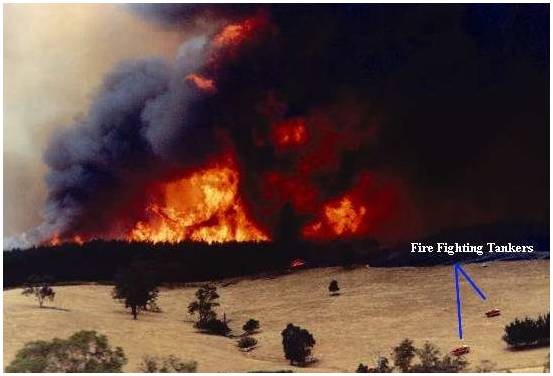
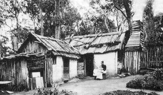
Pine plantation fire adjacent to Hume Highway at Wandong Victoria *
Summary of major Bushfires Since 1851. Victoria Australia
Select an article on this page.
1: Major bushfires in Victoria.
2: Chronology of Bushfires, hectares burnt and the death toll incurred.
3: " Black Saturday " 7 th of February. 2009 Bushfire.
4: The most vulnerable 52 Towns identified as high bushfire risk areas.
5: Map of 52 Towns identified as high bushfire risk areas.
6: The largest bushfires in Australia.
7: Australian Bushfire Map 1997 - 2008.
8: Deaths from wildfire / bushfire disasters worldwide
9: Victorian Bushfires Royal Commission 2009 Public-Hearings
10: The causes of bushfires, an 1855 and present perspective.
11: Current Active Bushfire Map and Victorian Roads closure.
Capital Territory |
||
Major bushfires in Victoria.
"Bushfires are a natural part of ecosystem
processes in Australia. However, as human settlements
expand into or adjacent to bushland areas, the risk to
lives and property increases." Source: The Australian Journal of Emergency Management, Vol. 22 No. 2, May 2007
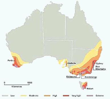
Image courtesy: Blong.R.J, Sinai.D and Packham c2000, (16)
According to the IPCC Fourth Assessment Report, an increase in fire danger is likely to be
associated with a reduced interval between fires, increased fire intensity, a decrease in fire
extinguishments and faster fire spread. In south-east Australia, the frequency of very high
and extreme fire danger days is likely to rise.
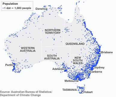
According to these predictions, fire danger will be a significant problem in south-east
Australia for the foreseeable future. The problem will be further compounded by water
scarcity which increases the likelihood of bushfires occurring (with very dry and easily
combustible vegetation) and, when they do occur, reduces the water supply available to
use to extinguish the bushfires.
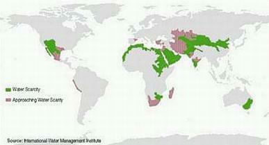
South-east Australia is one of several locations around the
World suffering from water scarcity. Water scarcity had a significant
influence on the occurrence and spread of the bushfires in Australia in 2009.
Source: Frederikssund-Halsnćs Workshop Handbook: European Exchange of Good Practice in Identification, Assessment and Management of Environmental Fire Risk
http://www.fire-risk.eu/resources/documents/document_display.htm?pk=30
Document: http://www.fire-risk.eu/ANSFR/FrederikssundWorkshopHandbookv2.pdf.
Accidental Natural and Social Fire Risk (ANSFR) European Project
6th of February, 1851 - "Black Thursday"
The largest Australian bushfire in European recorded history that burnt an area of approximately 5 million ha. which covered a quarter of Victoria.
The areas affected include
Portland, Plenty Ranges, Westernport, the Wimmera and Dandenong
districts. Approximately 12 lives, one million sheep and thousands of
cattle were lost.The elevation of Port Phillip district into the colony of Victoria, was on the 1st of July 1851.
Source: 1301.0 - Year Book Australia, 2004
" The blasts of air were so impregnated with smoke and
heat, that the lungs seemed absolutely to collapse
under their withering influence;... "
Source: From the Melbourne "Argus" Newspaper Feb. 8.1851
" The fire kept enlarging its orbit, rolling about like some huge monster, destroying everything it touched,
its track marked by charred timber, embers and ashes, cries and lamentations. Not content with dashing along
the ground , it ran up the highest trees and the flames leaped in monkey fashion from tree to tree. "
Source: From the "Melbourne Herald" Newspaper February 1883
![]() Read : Historical Newspaper articles about Black Thursday 1851
Read : Historical Newspaper articles about Black Thursday 1851
27th of February 1865 - "Black Monday"
" On Black Monday
the worst day for heat and smoke we
have had since Black Thursday, in 1851
-the destruction of property was very
great, and no one who has not seen a fire
raging among the stubbles and fences on
tilled lands, with a strong north wind
blowing, can well imagine what this is.
From Geelong to Ballarat was
nearly a line of fire, and numerous houses,
fences, and crops were either burnt up or
with difficulty saved. In the country
round Daylesford similar disasters occurred. .... "
Source: Perth Gazette & W.A. Times Friday 21 April 1865
1st of February 1898 - "Red Tuesday"
Fires burnt 260,000 hectares in South Gippsland. Twelve lives and more than 2,000 buildings were destroyed.
"... People however soon began to find that the water caught has an unmistakably smoky flavor, which may easily be accounted for by the fact that the atmosphere during the rain and for a long time before was much thickened by smoke from bushfires ..."
Source: The McIvor Times and Rodney Advertiser, 17 February 1898.
Early 1900s
Destructive and widespread fires are reported to have occurred in 1905 and 1906. Fires extended from Gippsland to the Grampians in 1912. In
1914, fires burnt more than 100,000 hectares. In 1919 extensive fires occurred in the Otway Ranges.
February - March 1926 - "Black Sunday"
Forest fires burnt across large areas of Gippsland throughout February and into early March. Sixty lives were lost in addition to
widespread damage to farms, homes and forests. The fires came to a head on February 14, with 31 deaths recorded at Warburton. Other areas affected include Noojee, Kinglake, Erica, and the Dandenong
Ranges. Widespread fires also occurred across other eastern states.
1932
Major fires occurred in many districts across Victoria throughout the summer. Large areas of State forest in Gippsland were burnt and nine
lives were lost.
Total area burnt in Victoria from the
fires between Dec 21, 1931 and Feb 6, 1932, there were 206,
000 Ha burnt from 307 fires.
Source: Foley 1947
13 January 1939 - "Black Friday"
From December 1938 to January 1939, fires burnt 1.5 to 2 million hectares, including 800,000 hectares of protected forest, 600,000 hectares
of reserved forest and 4,000 hectares of plantations.
The fire severity peaked on Friday January 13 - "Black Friday". The fires caused seventy one fatalities and destroyed more than 650 buildings and
the township of Narbethong.
“ Men who had lived their lives in the bush went their ways in the shadow of dread
expectancy. But though they felt the imminence of danger they could not tell that it
was to be far greater than they could imagine. They had not lived long enough. The
experience of the past could not guide them to an understanding of what might, and
did, happen. “
Source: Judge Leonard
Stretton, authority presiding over
the Royal Commission into the
Black Friday Fires.
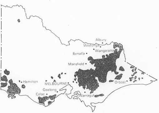
Map of Bushfire affected area from December 1938 to January 1939
The fires affected almost every section of Victoria. Areas hardest hit included Noojee, Woods Point, Omeo, Warrandyte, and Yarra Glen. Other areas affected include Warburton, Erica, Rubicon, Dromana, Mansfield, Otway Ranges and the Grampian Ranges.
3-4 March 1942
Fires in South Gippsland caused one human fatality, large losses of stock and destroyed more than 20 homes and 2 farms.
22 December 1943
The first major fire of the 1943/44 season occurred near Wangaratta, killing ten people and burning hundreds of hectares of grassland.
14 January - 14 February 1944
Fires in the Western Districts destroyed over 500 houses and caused huge losses in the pastoral industry. Four or more grass fires near
Hamilton, Dunkeld, Skipton and Lake Bolac burnt approximately 440,000 hectares in eight hours.
Records indicate that between fifteen and twenty people died as a result of these fires. The total area covered by grass fires that season
was estimated to be in the order of 1 million hectares.
One of the many bushfires of 1944 occurred on the outskirts of Melbourne at bayside Beaumaris. It burnt an area of 280 ha, directly threatening 118 houses, of which 58 were destroyed and 8 were damaged.
5 February 1952
A fire that originated on the Hume Highway near Benalla burnt approximately 100,000 hectares and caused the deaths of several people.
14-16 January 1962
Fires in the Dandenong Ranges and on the outskirts of Melbourne caused thirty three fatalities and destroyed over 450 houses. Areas severely affected include The Basin, Christmas Hills, Kinglake, St Andrews, Hurstbridge, Warrandyte and Mitcham.
17 January 1965
A major grass fire burning near Longwood in Northern Victoria caused seven fatalities and burnt six houses.
21 February - 13 March 1965
Fires in Gippsland burnt for 17 days, covering 300,000 hectares of forest and 15,000 hectares of grassland. Over 60 buildings and 4,000 stock were destroyed.
19 February 1968
A fire in the Dandenong Ranges burnt 1,920 hectares and destroyed 53 houses and over 10 other buildings. Areas affected include The Basin and Upwey.
8 January 1969
280 fires broke out on the 8th of January 1969. Of these, 12 grass fires reached major proportions and burnt 250,000 hectares. Areas seriously affected included Lara, Daylesford, Dulgana, Yea, Darraweit, Kangaroo Flat and Korongvale. Twenty-three people died, including 17 motorists at Lara, trapped on the Geelong to Melbourne freeway. The fires also destroyed 230 houses, 21 other buildings and more than 12,000 stock.
14 December 1972
A fire at Mount Buffalo burnt for 12 days, covering an area of approximately 12,140 hectares. This area included 7,400 hectares of State forest and 4,520 hectares of National Park.
12 February 1977
Widespread fires occurred across the Western District of Victoria, mostly in grasslands. The fires caused the deaths of four people and burnt approximately 103,000 hectares. More than 198,500 stock, 116 houses and 340 buildings were lost.
28 December 1980 – 6 January 1981
A fire started from a lightning strike on December 28, 1980 and continued to burn through until
6 January 1981. The fire burnt 119,000
hectares in the Sunset Country and the Big Desert.
31 January 1983
Fires in the Cann River forest district burnt more than 250,000 hectares including large areas of State forest.
1 February 1983
A fire at Mt Macedon burnt 6,100 hectares including 1,864 hectares of State forest. Fifty houses were destroyed.
16 February 1983 - "Ash Wednesday"
Australia's most well-known bushfire event. Over 100 fires in Victoria burnt 210,000 hectares and caused forty seven fatalities. More than
27,000 stock and 2,000 houses were lost. Areas severely affected included Monivae, Branxholme, East Trentham, Mt Macedon, the Otway Ranges, Warburton, Belgrave Heights, Cockatoo, Beaconsfield Upper
and Framlingham.
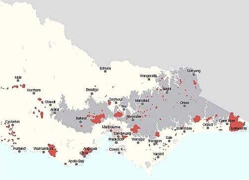
Image courtesy of 2009 Victorian Bushfires Royal Commission—Interim Report
Source: (15) Exhibit 11 – Statement of Esplin, Attachment 11
16th of February 1983 Southern Victoria and S.A. Bushfires
On 16 February 1983, 'Ash Wednesday', widespread, extreme fires fanned by winds gusting to over 100km/h (109 at Laverton, Vic and stronger on coast) and maximum temperature in Melbourne of 43.2 C with relative humidity readings of only 6%.
Similar conditions across much of Vic and SA resulted in a deadly rapid spread of the bushfires. They destroyed approximately 2,500 homes or major buildings.
In Victoria alone, these included 1719 houses (plus approx 300 in SA), 82 commercial properties (hotels, restaurants, stores, etc), and 23 dairies. Additionally, 1,238 farms were damaged in Vic contributing to a total of approximately 1,700 other (minor) buildings damaged in the two states. Also a large number of vehicles were destroyed.
Total deaths were 75 ( SA=28 and Vic=47*, incl 13 CFA & 2 other firefighters) and 2676 reported injuries. (*Note that the exact no. of deaths varies at official levels depending on when initially surviving victims succumbed to their injuries). Worst affected areas in Victoria included Framlingham (9 dead, 83 homes lost), Otway Ranges and Aireys Inllet (3 dead, 730 homes lost),Macedon and Mt Macedon (7 dead, 400 homes lost), Cockatoo (7 dead, 300 homes lost), Upper Beaconsfield and Belgrave Heights (21 dead, 180 homes lost).
In SA - Adelaide Hills (12 dead, 150 homes lost, incl 5 dead and 25 homes lost at Greenhill) and in the south-east of the State (14 dead, 40 homes lost mainly in the Mt Gambier area). Of 2676 injuries, 133 required hospitalisation
Over 300,000 livestock died (incl over 250,000 sheep and cattle in SA, 27,000 in Vic, plus thousands of others including poultry, pigs, horses, donkeys, deer, etc) while 15,900 km of fencing and 1.5 million hay bales burnt.
In SA alone, over 10,000km of fencing was destroyed across nearly 1000 rural properties.
More than 1 million ha burnt in Vic and SA during the 1982/83 summer with about half of that area affected during the main fires Feb 16-18 (210,000ha in Vic).
In SA alone, some indicative rural loss (1983) values, as reported by the SA Australian Agriculture Department included: Sheep $5.75m; cattle $2.1m; fencing, $10.2m; fixed assets, including homes, wool sheds, workshops & equipment $50m. These contributed to the State total estimated cost of $200m (1983 Review Team Report).
A total of 4,540 insurance claims were paid totalling $176m and a total estimated cost of well over $400m (1983 values) for both states combined.
14 January 1985
A major fire in Central Victoria burnt 50,800 hectares of land, including 17,600 hectares of Crown Land. Three people died and over 180 houses, 500 farms and 46,000 stock were destroyed as a result of the fire. Areas affected include Avoca, Maryborough, and Little River.
21 January 1997
Five major fires broke out including fires in the Dandenong Ranges that caused three fatalities, destroyed 41 houses and burnt 400 hectares. Other areas affected include Arthurs Seat, Eildon State Park, Gippsland and Creswick.
New Years Eve – 9 January 1998
A fire reported on New Years Eve continued for 10 days and burnt a total of 32,000 hectares. Of this area, 22,000 hectares was in the Alpine National Park (12,500 hectares of which is Wilderness or Remote Natural Area) and 10,000 hectares was in the Carey River State Forest. The suspected cause of the fire was a campfire.
Big Desert Fire - December 2002
Lightning in the North West caused two fires - one in the Big Desert Wilderness Park and another in the adjoining Wyperfield National Park on 17 December. Fanned by dry fuel and poor weather conditions, these fires joined to eventually burn 181,400 hectares.
An abandoned house was destroyed, as well as 400 hectares of private property. The fire was later declared safe on 31 December after 25mm rain fell in the area.
Eastern Victorian (Alpine) Fires 2003
Eighty seven fires were started by lightning in the north east of Victoria on 8 January 2003. Eight of these fires were unable to be contained and joined together to form the largest fire in Victoria since the 1851 "Black Thursday" bushfires. Burning for 59 days before being contained, the fires burnt over 1.3 million hectares, 41 homes and over 9,000 livestock, with thousands of kilometres of fencing also being destroyed. Areas affected include Mt Buffalo, Bright, Dinner Plain, Benambra and Omeo.
  |
Canberra fire shown as yellow markers.
Image courtesy of MODIS Rapid Response System at NASA/GSFC
https://earthdata.nasa.gov/earth-observation-data/near-real-time/rapid-response
During the 2002-2003 bushfire season,
there were 5,999 bushfires attended by the
relevant agency (a) Australia wide, 21,241,000 ha burnt and 7 Fatalities.
(a) this does not include, Tasmania, Northern Territory and Australian Capital Territory
Source: 1301.0 - Year Book Australia, 2004
" The geographic location and the topography of Australia mean that almost all vegetation types in the country are fire prone
....Even the normally arid interior of the country is capable of carrying extensive fires. "
Source: 1301.0 - Year Book Australia, 1995
Victorian Fires 2005
Across Victoria more than 500 fires broke out in January 2006 (including the Deep Lead fire that started near Stawell on New Year’s Eve).
The fires were fuelled by strong winds and extreme temperatures, including many days with temperatures above 40 degrees. The fires with greatest impact on the Victorian community occurred in the Stawell (Deep Lead),
Yea, Moondarra, Grampians, Kinglake and Anakie areas.
The fires caused the following losses and damage:
Fatalities: 4
Houses destroyed: 57 (19 of principle residence)
Buildings: 359 farm buildings lost, 39 woolsheds and 22 haysheds
Stock losses: 64,265 (63,243 sheep, 557 cattle and 464 other stock) and over 2,500 commercial beehives
Area burnt: 160,000 hectares (60% public land, 40% private land - Approximately 98,000 hectares of national parks and conservation areas and 6,000 hectares of State forest were burnt)
Fencing: 364km of crown land boundary fencing and 2281km of other boundary or internal fencing
Reference. http://www.dse.vic.gov.au/dse/
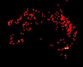
The Great Divide Fires of 2006 - 07
The Great Divide Fires of 2006/07 were the longest running bushfires in Victoria’s fire history.
On 1 December 2006, over 70 fires were caused by lightening strikes.
Many of these fires eventually merged to become the Great Divide Complex, which lasted 69 days and burnt approximately 1,048,000 hectares of public and private land.
Multiple other fires occurred simultaneously across the state.
Fifty-one houses, including twenty-one principle residences, and hundreds of stock and farm fences were lost in the fires. One man died in a vehicle accident while assisting a property owner to prepare for fire impact.
By the 7th February, more than 1400 firefighters had been injured (including bruises, cuts, blisters, burns, dehydration, broken limbs and spider bites).
More than 400 St John Ambulance volunteers, including doctors, nurses and first aid officers provided first aid.
On 16 December, eleven New Zealand firefighters were injured while fighting the fire in the Howqua Valley in north-east Victoria.
 |
The Great Divide fires are depicted as yellow
The fire map accumulates the locations of the fires detected by MODIS on board the Terra and Aqua satellites over a 10-day period. Each colored dot indicates a location where MODIS detected at least one fire during the compositing period. Color ranges from red where the fire count is low to yellow where number of fires is large.
7 th of February. 2009 " Black Saturday "
" February 7th 2009 will be remembered as the day when more than 400 fires burnt across the State during the most severe weather conditions recorded." (#)
173 people perished in the Victorian bushfire inferno " Black Saturday " on the 7 th of February. 2009 which, destroyed 2,029 homes, 2,498 buildings,
59 Commercial Premises and the loss of 5,223 stock.
It burnt out 411,239 hectares of land.
The destructive power of these fires.
" The total amount of heat released from the fires on "Black Saturday" would have been
sufficient to provide the total energy needs for all Victorian domestic and industrial use
for a year. This energy was released in just a few hours.
The energy of the fires was
equivalent to more than 1500 atomic bombs the size of the one used at Hiroshima,
which devastated an area equivalent to 2,000 ha, but bushfires release their energy in a
"storm" not a "blast". " (20)
| Hectares Burned | Hectares Burned | ||
| Delburn | 6,440 | Branxholme | 475 |
| Bunyp | 26,200 | Dargo | 13,640 |
| Beechworth/Mudgegonga | 33,300 | Kilmore/Murrindindi | 255,300 |
| Horsham | 2,200 | Colreaine | 775 |
| Pomborneit/Weerite | 1,300 | Churchill | 24,500 |
| Redesdale | 9,500 | Bendigo | 330 |
| Wilsons Promontory | 25,200 | Muskvale | 2,813 |
The Victorian Bushfires that occurred on 7 February 2009 are considered to be the worst natural disaster in Australian history. Significant loss and damage resulted in many regions of Victoria.
Fires affected at least 70 communities and 300 areas, including Marysville, Kinglake, Kinglake West, Kilmore, Yea, Murrindindi, Alexandra, St Andrews, Reedy Creek, Mittons Bridge, Humevale, Heathcote Junction, Flowerdale, Beechworth, Dargo, Bunyip, Mudgegonga, Narbethong, Cambarville, Koornalla, Jerralang Junction, Churchill, Callignee, Yarra Glen, Whittlesea, Upper Plenty, Toolangi, Strath Creek, Strathewen, Steels Creek, Bendigo and Redesdale.
Location and number of deceased found:
| Kinglake / Whittlesea Fires | |||
| Kinglake | 38 | Kinglake West | 4 |
| St Andrews | 12 | Canberville | 1 |
| Humevale | 6 | Strathewen | 27 |
| Flowerdale | 2 | Hazeldene | 10 |
| Steeles Creek | 10 | Arthurs Creek | 2 |
| Strath Creek | 1 | Toolangi | 2 |
| Marysville | 34 | Clonbinane | 1 |
| Heathcote Junction | 1 | Upper Plenty | 1 |
| Whittlesea | 2 | Narbethong | 4 |
| Yarra Glen | 1 | ||
| Gippsland Fires | |||
| Callignee | 3 | Callignee Upper | 1 |
| Churchill | 2 | Koornalla | 4 |
| Jeeralang Junction | 1 | ||
| Beechworth Fires | |||
| Mudgegonga | 2 | ||
| Bendigo Fires | |||
| Long Gully | 1 |
There were 414 patients who presented to hospital emergency departments as a result of the bushfires.(12)
According to the Insurance Council of Australia on 4 March 2009,
"... The general insurance industry has received approximately 8150 claims with an estimated insurable cost of $1.02 billion ".
However the full extent of costs to the communities will not be known for a considerable period of time.
" While the total area burnt in the 2009 fires is less than these earlier fires, the impact on lives and homes lost has been much greater. (15) "
The 2009 Victorian Bushfires Royal Commission was established on 16 February 2009 to investigate the causes of and responses to the bushfires that swept through parts of Victoria in February. The Commission is expected to deliver the final report by 31 July 2010.
Read article at Museum Victoria: " Recurring History of Bushfires in Victoria "
Source: EMERGENCY MANAGEMENT AUSTRALIA, http://www.ema.gov.au/ Accessed 14th May 2009
Source: http://www.police.vic.gov.au/content.asp?Document_ID=20350 Accessed 14th May 2009
Source: Department of Sustainability and Environment Document was last reviewed on 17/03/2009
Source: Full Day Hansard Transcript (Legislative Council, 10 March 2009)
(12) Source: Black Saturday: the immediate impact of the February 2009 bushfires in Victoria, Australia
The Medical Journal of Australia MJA 2009; 191 (1): 11-16 Accessed: 14th July 2009
(#) Source: Condolence Speech - Victorian Fires The Hon Julia Gillard MP 9 February, 2009
 |
Kinglake - Marysville Bushfire Complex 5th to 10th February 2009
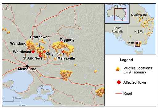
Map of the FEBRUARY 2009 FIRES
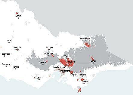
Image courtesy of 2009 Victorian Bushfires Royal Commission—Interim Report
Source: (15) Exhibit 11 – Statement of Esplin, Attachment 1
Victorian Bushfires Royal Commission 2009 Public Hearings
The first block of public hearings began on Monday, 11 May 2009, in Room 4.3 at the County Court of Victoria, 250 William Street, Melbourne.
Transcripts from the Royal Commission for download are available
Click here.
The most vulnerable 52 Towns identified as high bushfire risk areas.
During the 2009/10 fire season, township protection plans will be piloted in 52 identified priority bushfire risk locations.
Source. C.F.A http://www.cfa.vic.gov.au/
| Summer tourist areas | |
| Airey’s Inlet townships | Anderson’s Inlet townships |
| Anglesea | Blairgowrie |
| Carlisle River | Lorne |
| Marengo | Rye/St Andrews |
| Sandy Point | Wye River Townships |
| Towns in bushland | |
| Barongarook | Bemm River |
| Blackwood | Bolwarra |
| Cann River | Cockatoo |
| Creswick | Dereel |
| Gembrook | Greendale |
| Hepburn | Macedon |
| Mount Macedon | Noojee |
| Steiglitz | Trentham |
| Towns near bushland | |
| Barwon Downs | Breamlea |
| Castlemaine | Daylesford |
| Deans Marsh | Dunkeld |
| Forrest | Halls Gap |
| Jan Juc | Junortoun |
| Kawaren | Laver’s Hill |
| Loch Sport | Mallacoota |
| Nelson | Peterborough |
| St Arnaud | Upper Beaconsfield |
| Woodend | |
| Suburbs in bushland | |
| Warrandyte | North Warrandyte |
| Mt Helen | Mt Clear |
| Suburbs near bushland | |
| Eaglehawk | Maiden Gully |
| Kangaroo flat | Dandenong Ranges ** |
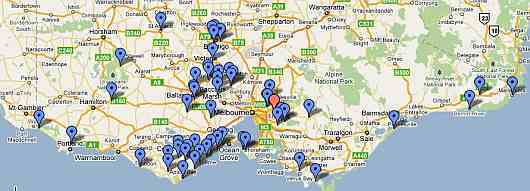
Click here to view detailed and enlarged map in google maps.
** Communities on the western escarpment and the ridge line of the Dandenong Ranges.
How these areas were identified.
The fire agencies have
assessed the whole of the state of Victoria to determine the risks of
bushfire in the 2009-10 fire season.
Rigorous scientific evidence has been used to identify the most vulnerable areas by taking account of factors including:
1: Population density which relates to both the number of people
and where there are large transient populations. Transient populations
are important because they do not understand the area the way the
locals do and wont know about the plans for fire.
2: Potential for extreme fire behaviour. A number of things are
considered including how much dry vegetation there is, how steep the
slope is, and what direction the slope is facing. Slopes that face
north and west are drier than slopes facing south and east.
3: Proximity, type and volume of fuel load making communities
more vulnerable if large fires are able to gain strength prior to it
impacting on communities.
4: How easy it is to leaving safely which goes to questions of the number of usable roads.
5: How easy it is to get help
, which is about the number of usable roads and how isolated the
community is.
6: How well prepared the community
is.
7: Recent planning requirements will have mitigated the risk of fire.
The fire agencies have found that the most vulnerable areas have been identified because,
8: They have high population
densities, which may also arise because of the influx of summer tourists.
9: They are located in areas where
the physical characteristics of the area assist in building fire
intensity.
10: Fires are potentially well fed by fuel load before they reach
the town or community. Some communities are more likely to impacted by
a well established bushfire.
11: They have limited ability to leave the area safely by road
because of the limited number of roads or the likelihood that those
affected do not know the local area well.
12: Fire trucks may not be able to
be brought into an area and so it will be dependent on local resources
only.
13: They have communities that have
not had experience over time in preparing for extreme fire events.
14: They are old townships or
communities built with materials and standards not designed to minimise
the impact of fire.
| Year | Location | Start Date | Dead | ha. Burned |
| 1851 | Widespread Bushfires "Black Thursday" | 06/02/1851 | 15 | 5 million |
| 1865 | West,Central,South "Black Monday" | 27/02/1865 | ||
| 1879 | The whole of the south Gippsland (2). | |||
| 1886 | Otway and Heytesbury, incorporating Panmure, Colac, Camperdown | 04/01/1886 | ||
| 1898 | South Gippsland, "Red Tuesday" | 01/02/1898 | 12 | 260,000 |
| 1899 | Beechworth–Yackandandah, Broadford, Bairnsdale | December 1899 | ||
| 1900 | Hamilton, Bealiba, Warrenbayne, Wangaratta, Euroa, Warrnambool | January 1900 | 202,342 | |
| 1905 | Widespread (incl Dandenong Ranges) | 01/12/1905 | 12 | 24,281 |
| 1912 | Willaura, Vic: Bushfire | 01/01/1912 | ||
| 1913 | Chelsea (Melbourne), Vic: Bushfire | 01/01/1913 | ||
| 1914 | Gippsland, Grampians, Otway Ranges | 01/01/1914 | 100,000 | |
| 1919 | Otway Ranges, | 01/02/1919 | 3 | |
| 1919 | Grampians, | 15/11/1919 | 48,500 | |
| 1923 | Mansfield Bushfire | 01/01/1923 | 1 | |
| 1926 | Noojee, Kinglake, Warburton, Erica, Dandenong Ranges | 01/02/1926 | 60 | 400,000 |
| 1932 | Widespread (incl Gippsland), Victoria:(3) | 01/01/1932 | 9 | 206,000 |
| 1933 | Gippsland | 01/01/1933 | 1 | |
| 1939 | Narbethong Bushfire | 08/01/1939 | 2 | |
| 1939 | Southern Victoria: "Black Friday" | 13/01/1939 | 71 | 2 million |
| 1942 | Hamilton, South Gippsland – Yarram | 03/03/1942 | 1 | |
| 1943 | Western, Central,Southern Victoria: Event End Date 15/02/1944 |
22/12/1943 | 51 | 1 million |
| 1952 | Central and Southern Victoria: Benalla | 01/01/1952 | 10 | 100,000 |
| 1962 | Christmas Hills, Kinglake, St Andrews, Hurstbridge, Warrandyte, Mitcham | 14/01/1962 | 33 | |
| 1965 | South-Eastern and Central Victoria. | 15/02/1965 | 3 | 315,000 |
| 1965 | Longwood District, Victoria: Grassfire | 17/01/1965 | 7 | |
| 1968 | Dandenong Ranges, The Basin, Upwey | 19/02/1968 | 1,920 | |
| 1969 | 280 fires, Daylesford, Bulgana, Yea, Darraweit, Kangaroo Flat, Korongvale | 08/01/1969 | 23 | 250,000 |
| 1972 | Mt Buffalo | 14/12/1972 | 12,140 | |
| 1977 | Penshurst, Tatyoon, Streatham, Creswick, Pura Pura, Werneth, Cressy, Rokewood, Beeac, Mingay, Little River | 12/02/1977 | 8 | 135,000 |
| 1978 | East Gippsland, Bairnsdale | 15/01/1978 | 2 | |
| 1980 | Sunset country and the Big Desert | 28/12/1980 | 119,000 | |
| 1983 | Greendale | 08/01/1983 | 2 | |
| 1983 | Cann River | 31/01/1983 | 120,000 | |
| 1983 | Mt Macedon Bushfire | 01/02/1983 | 7,964 | |
| 1983 | Southern Victoria "Ash Wednesday" (4a) | 16/02/1983 | 47 | 210,000 |
| 1983 | Cann River | 04/03/1983 |
|
140,000 |
| 1985 | Avoca–Maryborough, Little River, Springfield, Melton | 14/01/1985 | 5 | 50,800 |
| 1988 | Southern Victoria | 02/11/1988 | ||
| 1990 | Strathbogie Ranges. | 27/12/1990 | 1 | |
| 1994 | Lorne | 11/01/1994 | ||
| 1995 | Berringa | 23/02/1995 | 10,000 | |
| 1995 | South-Western Victoria Bushfires | 01/10/1995 | ||
| 1997 | Winton and Romsey Bushfires | 16/02/1997 | 800 | |
| 1997 | Dandenong Ranges, Creswick, Heathcote, Teddywaddy, Gough’s Bay | 19/01/1997 | 3 | 4,150 |
| 1997 | Sunbury, Vic: Bushfire | 24/03/1997 | 100 | |
| 1997 | Caledonia River area of Alpine National Park, Carey River State Forest | 31/12/1997 | 32,000 | |
| 1998 | Western District, Wilson's Promontory | 01/02/1998 | 1,600 | |
| 1998 | Trentham | 22/03/1998 | 3,500 | |
| 1998 | Southern Victoria Bushfires | 12/03/1998 | ||
| 1998 | Linton, Vic: Bushfires(4) | 02/12/1998 | 5 | 780 |
| 1999 | Grampians | 05/01/1999 | 7,000 | |
| 2000 | Melbourne and NW Vic: | 10/02/2000 | ||
| 2000 | Portland Region | 18/01/2000 | 1,700 | |
| 2000 | Horsham,Stawell,Ballarat Regions | 28/11/2000 | 29,000 | |
| 2002 | Glenaroua | March 2002 | 6,100 | |
| 2002 | Big Desert | 17/12/2002 | 181,400 | |
| 2003 | Over 80 fires started by lightning—north-east Victoria, Gippsland | 08/01/03 | 1 | 1,300,000 |
| 2005 | Wilsons Promontory | April 2005 | 6,000 | |
| 2005 | Stawell,Yea,Grampians,Kinglake,Anakie | 31/12/05 | 4 | 160,000 |
| 2006 | Great Divide Complex Bushfires: | 01/12/06 | 1 | 1,200,000 |
| 2009 | Black Saturday Victorian Bushfires | 07/02/09 | 173 | 411,239 |
| ha. = hectares | Total Deaths | 566 | ||
( Data revised 1st May 2011 )
This list is not definitive but gives an idea of the major fire events, particularly after 1939 when the reliability of information increases.
Some minor bushfire events have also been included.
During this period there were 561 Human fatalities
Australia Wide Bushfires 1851 - 2009
During this period there were 815 Human fatalities and 9,946 people were injured. These Fires had affected 1,311,050 people and made 31,942 homeless.
The Total estimated Cost $1,673,697,366. Note this does not include the 7th of February 2009 fire loss, which has yet to be assessed.
Australia Wide Floods since 1790
There were over 2,300 recorded Human fatalities.(1)
Australia Wide Tropical cyclones since 1839
There were over 2,100 recorded Human fatalities.(1)
Australia Wide Severe storms since 1824
There were over 770 recorded Human fatalities.(1)
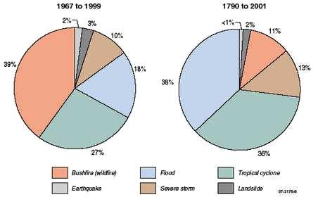
Proportion of fatalities caused by natural hazards.
Meteorological hazards, including bushfire, flood, tropical cyclone and severe storm, accounted for 95% of fatalities during the 33-year period, as shown in the graph above, with bushfires contributing the most fatalities (BTE 2001). The graph also shows that over a much longer period, from 1790 to 2001, flood-related fatalities surpassed the number of recorded deaths from bushfires and tropical cyclones (Blong 2005). The proportions of deaths arising from non-meteorological hazards remain very low in the second sample. Source based on BTE (2001) TABLE 3.2 and Blong (2005) Table 1. (19)
The causes of bushfires.
CAUSES OF BUSHFIRES IN VICTORIA - 1976-77 to 1995-96 | ||||
Average no. of fires
each year | Proportion of total fires | Average area burnt | Proportion of total area burnt | |
| Fire cause | no. | % | ha/yr | % |
| Lightning | 149 | 26 | 53,096 | 46 |
| Deliberate | 145 | 25 | 15,649 | 14 |
| Agricultural | 96 | 16 | 7,799 | 7 |
| Campfires | 59 | 10 | 1,466 | 1 |
| Cigarettes/matches | 41 | 7 | 444 | <1 |
| Cause unknown(a) | 37 | 6 | 2,974 | 3 |
| Miscellaneous(b) | 26 | 5 | 10,009 | 9 |
| Machinery/exhausts | 15 | 3 | 2,551 | 2 |
| Prescribed burn escapes(c) | 9 | 2 | 5,274 | 5 |
| Public utilities(d) | 7 | 1 | 16,256 | 14 |
| Total(e) | 584 | 100 | 115,518 | 100 |
| (a) Includes fires where investigators could not ascertain the cause, as well as fires where the cause was not investigated. (b) Includes causes like: burning houses, burning buildings and fireworks. (c) Management of parks and forests includes the use of planned fires for a variety of purposes such as natural fuel management and the maintenance of flora and fauna habitat. Sometimes these fires burn beyond the planned perimeter. (d) Includes ignitions from trains and power transmission. (e) All figures are rounded; hence may not add up to column totals. | ||||
| Source: DSE 2003a. Source: Year Book Australia, 2004 http://www.abs.gov.au/ausstats/abs@.nsf/0/ccb3f2e90ba779d3ca256dea00053977?OpenDocument | ||||
An 1855 description of the causes of bushfires. The Sydney Morning Herald 1855
" The bush in its natural state thus dried up becomes susceptible of ignition.
But the wind does not produce ignition. What, then, does ?
There are but two examples offered of the way in which ignition may naturally take place, and, we doubt not, has taken place.
1st. Boughs of trees grating against each other under the agitation of wind may produce ignition once in a while, just as fire is produced by the aborigines by the friction of one stick upon another, and as may be shown by any active " bushman" who has tried the experiment.
2nd. Glass bottles, lying in grass upon the ground under a burning sun, act as powerful lenses, and readily set the dry herb in a blaze under the operation of a fanning breeze....
But the most common causes of ignition are these :
Fires made by careless people at picnics, by bullock drivers and other travellers,...(18), who do not take care to extinguish their fires when they break ground, and by careless fellows that rejoice in cigars and tobacco pipes, who throw away their ashes with as much unconcern, as if they thought their highest ambition was " ex fumo dure lucem."
These causes of conflagration may be thought hypothetical; yet the evidence on fires in London and other great cities taken by authority proves that a great proportion of such fires are occasioned by lucifer matches thrown down and stamped on, and there are many examples given of fires produced by rats and mice gnawing such matches. Perhaps, therefore, in this land of smokers, lucifer matches may be taken as an additional agent in bush-fires.
Captain STURT distinctly states, a match took fire in the interior during his last journey, on being thrown upon the heated ground. So much for the incendiaries ; now for the sufferers.
Experience tells us that nine times in ten precaution in the case of fires is better than a remedy, and that danger ensues from the carelessness of the occupiers of lands and houses near the bush ; and, therefore, we say generally, if men prefer living in wooden houses or in tenements of any kind in the midst of the bush, with rank vegetation, that may be converted into tinder by a dry wind, close up to their fences ; if they prefer having around them a thick moustache of scrub to a clean shaven lip of sward-let them not complain, if, when accident or design sets the bush in a blaze, they are to be seen as they were on Sunday week, in the fire of the trenches, instead of keeping a quiet day at church and in the family.
It is impossible for legal enactments to effect much reform on smokers, bullock-drivers,...(18),and picnic worshippers, on glass bottles, or chafing trees ; but if the inhabitants of our towns and villages are not wise enough, of their own accord, to surround themselves with a fortification of cleared scrub and bush, then the law ought to take the matter out of their hands and enact, that no man shall be allowed to have any brush or scrub within some feet of his fences, or wooden buildings, on pain of punishment.
This might be fairly made a subject of legislation in the new Parliament, where probably, there will be matters quite as fiery to debate, without half the usefulness. .....
In general, a bush-fire is a water-maker ; in the last instance, the wind was so strong as to blow the water so made away from the land ; hence we have not had the usual rain-and excellent rain it is from its carbonaceous distillation -after a bush-fire. We trust, if needed, it will yet come. "
Source: The Sydney Morning Herald Monday 26 November 1855 (17) Note:(18) refers to indigenous people.
Partially Referenced from:
EMERGENCY MANAGEMENT AUSTRALIA,
http://www.ema.gov.au/ Accessed 14th May 2009
Bushfire area burnt - Source: CFA website; DPI/DSE website; R.H. Luke and A.G. McArthur, Bushfires in Australia, AGPS, 1978; Reports of the 1939 and 1944 Royal Commissions;
A.G. McArthur, N.P. Cheney and J. Barber, The fires of 12 February 1977 in the Western District of Victoria, CSIRO and CFA, 1982; R. Murray and K. White,
(1) Reference. Blong, R (2005) ‘Natural hazards risk assessment - An Australian perspective’.
Issues in Risk Science 4, Benfield Hazard Research Centre, London, p. 28.
(1) Source. 1301.0 / 2008 / Yearbook Complete / Understanding natural hazard impacts on Australia.
* Image: Pine plantation fire adjacent to Hume Highway at Wandong
Victoria 2003
courtesy of " Bushfire Threat to Nillumbik Shire " David Packham Rural Fire Consultant
Source: http://www.nillumbikratepayers.asn.au/btn.htm
(2) Source: The land of the Lyrebird, page 142, cited by Foley 1947.
(3) Source. Foley 1947
(4) Source: http://www.dse.vic.gov.au/ ( Linton bushfire not found in E.M.A Database accessed 20/2/2009 )
Source. Emergency Management Australia, Attorney-General’s Department. EMA disasters database. Events by category. http://www.ema. gov.au/ema/emadisasters.nsf (accessed 14th May 2009).
(4a) Source: 1301.0 - Year Book Australia, 2004 accessed 20/6/2009 )
Image Bushfire causes. Source: Department of Sustaimabillity and Environment. http://www.dse.vic.gov.au/
Deaths from wildfire/bushfire disasters worldwide
| Year | Location | Deaths |
| 1871 | Peshtigo, Wisconsin, USA (5) | 1200 |
| 1918 | Cloquet, Minnesota, USA (6) | 453 |
| 1894 | Hinckley, Minnesota, USA (7) | 418 |
| 1881 | Thumb region, Michigan, USA (8) | ~300 |
| 1916 | Matheson, Ontario, Canada (10) | 282 |
| 1997 | Sumatra, Kalimantan, Indonesia (9) | 250 |
| 1987 | Greater Hinggan, China (11) | 213 |
| 2009 | Victoria, Australia | 173 |
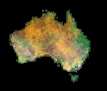
The largest bushfires in Australia.
 Image Courtesy Bureau of Meteorology http://www.bom.gov.au/lam/climate/levelthree/c20thc/fire3.htm Area burnt during the 1974-75 fire-season in Australia (adapted from “Bushfires in Australia”, Luke & McArthur,1978). During the extreme year of 1974-1975 "over 117 million ha or 15% of the total land area of the continent was burnt in central Australia during the fire season. " Source: 1301.0 - Year Book Australia, 2004 Africa is often referred to as the "fire continent" owing to the regular and widespread occurrence of wildland fires. A recent research report by the United States National Aeronautics and Space Administration (NASA) indicated that about 130 million hectares of savannahs and grasslands burn annually in Africa south of the equator, (for comparison, the country of South Africa covers an area of 122 million hectares). The heaviest burning is concentrated in the moist subtropical belt which includes Angola, the southern Congo, Zambia, northern Mozambique and southern United Republic of Tanzania. During the 2000 fire season, the area burned south of the equator may have reached more than 200 million hectares. (14)  https://earthdata.nasa.gov/earth-observation-data/near-real-time/rapid-response This composite satellite map shows where bushfires had occurred during the years 1997 to 2008.
 |
Reference:
Note the fire in 1949 Landes region, France the death toll was 80.
Source: Forestry 1977 50(1):89-91; doi:10.1093/forestry/50.1.89
© 1977 by Institute of Chartered Foresters.
The 1825 Miramichi, New Brunswick, Canada fires MIRAMICHI."---The following account of the loss and Lives and Property sustained by the late conflagration at Miramichi, is extracted from an abstract published there, by order of the "Committee appointed for the relief of the sufferers."
Persons burnt, 130; drowned, 10; deaths from injury received by the fire, 20---Total, 160."
http://www3.gendisasters.com/fires/4314/miramichi,-nb-fire,-oct-1825
(5) Source: 1871 Peshtigo, Wisconsin, USA http://www.peshtigofire.info/ Accessed: 14th July 2009
(6) Source: 1918 Cloquet, Minnesota, USA COMMEMORATING THE 80TH ANNIVERSARY
OF THE FIRES OF 1918
by Lois E. Johnson
President, Moose Lake Area Historical Society http://www.mnhs.org Accessed: 14th July 2009
(7) Source: The Great Hinckley Fire of 1894 http://www.hinckley.govoffice2.com/ Accessed: 14th July 2009
(8) Source: 1881 Thumb region, Michigan, USA http://www.ns.umich.edu/htdocs/releases/story.php?id=1245
http://www.associatedcontent.com/article/28070/attractions_in_port_hope_michigan.html
Accessed: 14th July 2009
(9) Source: 1997 Sumatra, Kalimantan, Indonesia Death toll: >250 human due to aircraft and maritime accidents associated with the fires. GFMC: Bush and Forest Fires in Australia www.fire.uni-freiburg.de/GFMCnew/.../20050112_aus.htm www.fire.uni-freiburg.de/iffn/iffn_22/iffn22.pdf Accessed: 14th July 2009
(10) Source: 1916 Matheson, Ontario, Canada. Natural Resources Canada. www.nrcan.gc.ca Accessed: 14th July 2009
(11) Source: 1987 Greater Hinggan, China Global Fire Monitoring Center (GFMC) http://www.fire.uni-freiburg.de/ http://www.fire.uni-freiburg.de/GFMCnew/2002/1002/20021002_cn.htm
Accessed: 14th July 2009
(12) Source: Black Saturday: the immediate impact of the February 2009 bushfires in
Victoria, Australia.
The Medical Journal of Australia MJA 2009; 191 (1): 11-16
Accessed: 14th July 2009
(13) Source: Fire in Australia's Tropical Savannas http://www.savanna.org.au/all/fire.html
(14) Source: 2001. Global forest fire assessment 1990-2000. FRA Working Paper No. 55.
www.fao.org/forestry/fo/fra/index.jsp
(15) Source: 2009 Victorian Bushfires Royal Commission—Interim Report.
http://www.royalcommission.vic.gov.au/Public-Hearings
- File: Chapter1_HR.pdf
(16) Source: Construction of Buildings in Bushfire - Prone Areas Seminar. March – April 2009.
Presented by: Stuart McLennan and Norm Winn - File: Bushfire_Presentation_FINAL-_RBP_.pdf
Image courtesy: Blong.R.J, Sinai.D and Packham c2000, Natural Perils in Australia and New Zealand.
(17) Source: The Sydney Morning Herald Monday 26 November 1855 - http://newspapers.nla.gov.au/
(19) Source: Natural Hazards in Australia Identifying Risk Analysis Requirements Miriam H. Middelmann (Editor)
Risk and Impact Analysis Group
Geospatial and Earth Monitoring Division
Geoscience Australia
GPO Box 378, Canberra ACT 2601
Source: 100 years of Australian civilian bushfire fatalities file http://www.bushfirecrc.com/research/downloads/Fatality-Report_final_new.pdf.
Accessed: 14th July 2009
Source: Report of the National Inquiry on Bushfire Mitigation and Management
http://www.coagbushfireenquiry.gov.au/index.htm
file http://www.coagbushfireenquiry.gov.au/report/docs/appendix_D.doc.
Accessed: 14th July 2009
Source: 1301.0 - Year Book Australia, 2004
file http://www.abs.gov.au/websitedbs/D3310114.nsf/home/home?opendocument?utm_id=GB
Accessed: 14th July 2009
~ represents about 300
• Reference: Museum Victoria: Recurring History of Bushfires in Victoria
• Reference: Bushfire Memorials Consultation process – A Guide for Local Government Councils and communities. - pdf - file
• Reference: Cause of bushfires in Australia.
Australian Institue of Criminology www.aic.gov.au/.../05_reportonperformance.aspx
• Reference: Arson and Bushfires in Australia.
A presentation written and delivered by Dr Janet Stanley, Chief Research Officer at
the Monash Sustainability Institute56, Clayton, Victoria, Australia.
http://www.monash.edu/research/sustainability-institute/
Document: http://www.fire-risk.eu/ANSFR/FrederikssundWorkshopHandbookv2.pdf.
Summary of major Bushfires Since 1851. Victoria Australia ( 30 pages )
by Romsey Australia is licensed under a Creative Commons Attribution 2.5 Australia License.

Revised 28/04/2011